California waterfall?

M. R. Byrd

Well-known member
This post has nothing to do with California bird hunting, but know there are a number of you from California here on UPH. I am trying to identify the location in this photo. The man on the left is my grandfather. He spent some time in the late 30's at his brother-in-law's ranch about 50 miles northeast of Bakersfield. The ranch is just into Tulare County on the county line with Kern County in the area just east of Sugarloaf Mountain(Alta Sierra and Kernville area). About ten years after the brother-in-law's death the ranch went to the California state YMCA camp as I recall(about 1955). Now it is a state environmental education camp for middle schoolers I believe.

I have a feeling the photo was taken somewhere in that area.

Scan-029_zpsa0a2exnc.jpg
 
Just a waterfall with two guys on horses is hard to locate. A better hint is if you can tell us why there seems to be a bull elk standing behind them. I don't think Tule Elk get to where they have waterfalls like that and the only Roosevelt Elk back then may not have existed in Calif.
Are you sure this was in calif? Is that a statue which seems odd to be in a location like that.
Are you screwing with us because it looks like the ground is a different texture just behind the horses and in front of the elk? Photoshopped?
 
Last edited:
Kind of a head scratcher there Maynard. My initial guess is that the pic was taken somewhere near the former Buena Vista lake and the elk is a statue (the last wild tule elk were found near Buena Vista). My other guess would be somewhere on Sherman Pass.
 
Kind of a head scratcher there Maynard. My initial guess is that the pic was taken somewhere near the former Buena Vista lake and the elk is a statue (the last wild tule elk were found near Buena Vista). My other guess would be somewhere on Sherman Pass.

Buena Vista Lake is west of Bakersfield in ag lands with nothing like a waterfall like that. Although it's near the Tule Elk Reserve near Tupman, again no waterfall. Why would they put a statue of a Tule Elk where they didn't occur like Sherman Pass? Looks faked.
 
Look at the elks rump. It is a much lighter color than the rest of the elk which is how a live animal looks. Statues of this sort are generally cast bronze which doesn't allow differences in color like that unless they were painted. It actually looks like a mounted animal which is really out of place in that setting. Why isn't there a plaque or something to indicate the context of the statue? It's just stuck out there and guys could ride horses to it? Makes no sense at all.
Grandpa Davie was having some fun back then and faked a photo..
 
Quite a ruse to haul a full mount up to a waterfall for a photo op.

Tules were in Owens Valley at the time which a guy from kernville would take the pass to, there are some rugged hills just south and west of Buena Vista that could have some falls possibly, and there might've even been some rocky mountain elk in Tehachapi by then.

I'm just trying to give out a few ideas here.
 
I suspect that the other man in the photo is my grandfather Davie's brother-in-law who was a civil engineering graduate of the University of Kansas(KU) and was the county engineer for Kern County, California, a real estate developer there in Bakersfield and Oildale and Poso Park. He was also an investor in oil wells. He owned the ranch in Tulure County north of Kernville, which is where he died in an early snow storm gathering the horses. He was a chess player and would play chess by mail taking years to complete a match. He was also a photographer and liked to make double images. There is one some where of him playing chess with himself. That fact makes me wonder if this photo is a double image. If it is I would have thought that he would not have had the elk hidden to the extent it is. The elk appears to have hide and hair, either a live animal or a full body mount. I would guess the time of the photo to be between 1935-1940. If my 101 year old mother's eyesight was good enough to see it she might be able to answer my question, but I will describe it to her and see if she might know what I am talking about.
 
Here is a picture of the Tulare County ranch house taken in 2005. After Amel Stegeman's death(1945) it went to the YMCA(1955) and now a state education environmental camp for middle schoolers and the house is used as a dormitory for the camp counselors.

Scan-037_zpshtrcomhd.png
 
Removing the elk as to any bearing of the picture it could be anywhere in the area. The Kern river and creeks in that area make up tons of falls, the only one I really know being "the seven teacups" which that one definitely isn't.
 
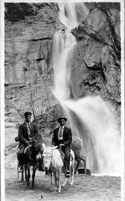
Since Grandpa Davie's brother in law was a photographer who liked to make double exposures, it's entirely possible that this is actually a triple exposure exercise/experiment. Photographers did that sort of thing before computer manipulation to make photographs of seemingly impossible scenes.
Some info on the Sherman Pass Road. Doesn't look like it went over the crest at the time the photo was supposed to have been taken. Without more context for the water fall there is no way to know where in California it is or even if it's in California at all.

When the state sign route system was created in 1934, Sign Route 190 was assigned to the portion of Route 127 west of Death Valley Junction, while the remainder to Baker became part of Sign Route 127.[15] However, the highway was not continuous, with the roadway from Tipton (which had been built by Tulare County[16]) ending at Quaking Aspen (east of Camp Nelson) and that from Death Valley ending southwest of Lone Pine.[17] In 1923, Tulare County businessmen had begun to push for a new trans-Sierra highway connecting Porterville with Lone Pine,[18] but were set back by a lack of state aid, as the road was not a state highway.[19] The first piece, which would turn out to be the only one built, opened in early July 1931 to Quaking Aspen (and became a state highway in 1933).[20] Grading of the 15-mile (24 km) Western Divide Highway, a county road that was supposed to continue south to State Route 155 at Greenhorn Summit,[21] was completed from Quaking Aspen south to near Johnsondale in July 1962.[22] A new road from Johnsondale across Sherman Pass, maintained by the U.S. Forest Service and Tulare and Inyo Counties (the latter as County Route J41), was completed in 1976, allowing traffic on the western segment of SR 190 to reach US 395, though via a longer route than the proposed SR 190.[23]
 
Just a guess, but, the waterfall could be "Salmon Falls" along the Kern River right off the river road heading towards McNally's cafe.
 
Just a guess, but, the waterfall could be "Salmon Falls" along the Kern River right off the river road heading towards McNally's cafe.

I looked it up on Google Earth and that might be it. My mother is a little under the weather today, but when I see her I will ask about Salmon Falls to see if that rings any bells. Thanks.
 
Back
Top